Prologue
Sorry for not getting to this earlier, this is hopefully going to be a quick review of two of Pittsburgh‘s (relatively) unique elements of transport:
THE INCLINE RAILWAYS
(c’mon this is supposed to be dramatic! but alas, you can’t have much drama with a website)
If you don’t know about Tram Review, you can visit the about page. 😄
Overview
I’d like to share this inspiring, emotional quotation that will tell you everything:
“It’s Pittsburgh[,] [e]verything is blocked by a hill[.]”
– Daria Phoebe
So… as you can see, Pittsburgh is hilly, quite hilly. Such a geographic situation usually means that portions of the city are separated from each other by elevation changes (as opposed to more mountainous localities where growth becomes actually constrained).
The need to cover these slopes, combined with cable cars, the other way to solve this issue, not existing at the time1 resulted in the construction of about twenty funiculars, called “incline railways” here.
Two of them survive today, so let’s get into it:
[fancy music combined with fancy graphics]

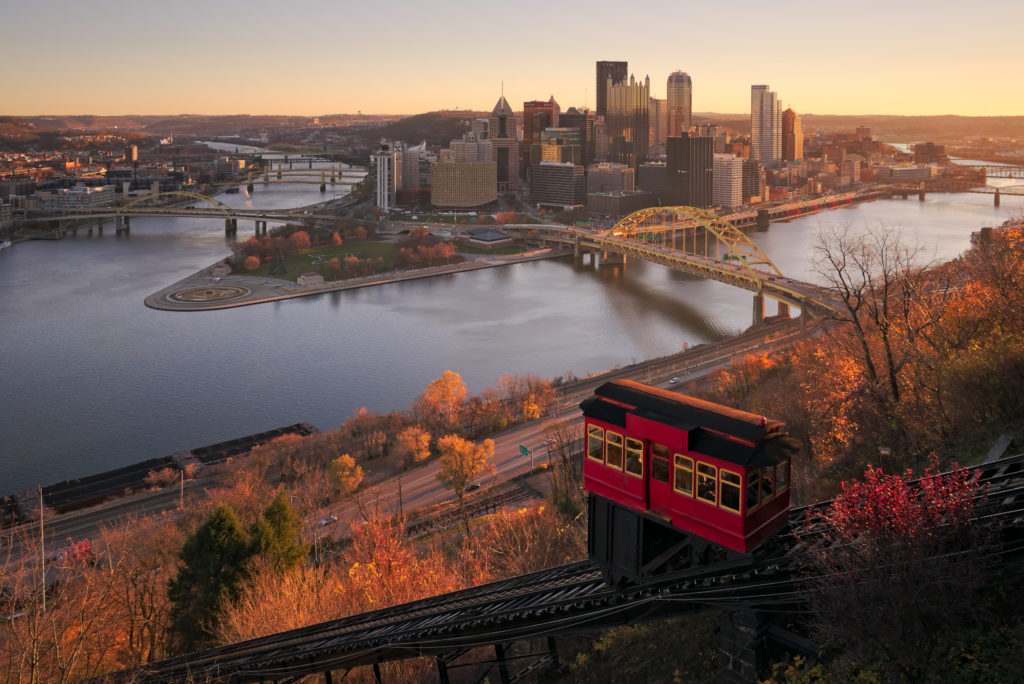
Monongahela Incline
Let us start with the older of the two, the Monongahela Incline. It is fully double track, and is 1524mm2 gauge.
The railway has two stations and climbs 114.3 meters in 195.07 meters up the slope, which is about 158.07 meters horizontally, resulting in about a 70% grade, making it the steeper incline of the two.
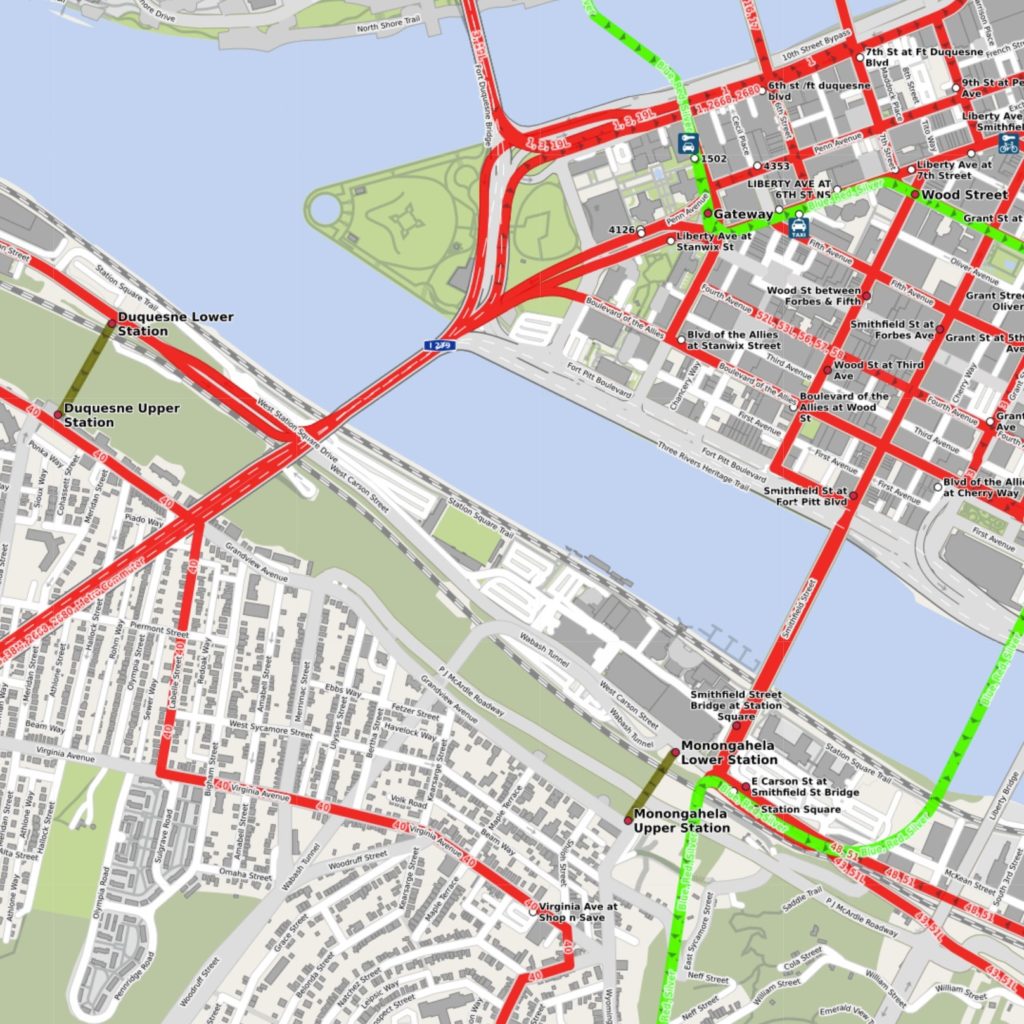
The funicular is located in Pittsburgh’s South Shore, across the Monongahela from Downtown. It connects the waterfront (Station Square) to the Mt. Washington neighborhood.
The incline is currently operated by the Port Authority of Allegheny County, and accepts standard PAAC farecards (fares are $2.50 with farecard, $2.75 with cash, $3.50 for a round trip within 3 hours, or $5.00 for a round trip in the same day, both with farecard), which means it can theoretically provide transit value, however both Station Square and the Mt. Washington neighborhood are served by the 40 Mt. Washington bus. Transfers are an issue though, costing $1.00. As mentioned, the incline connects to the 40 bus at its top station. It also connects to the light rail trunk, the South Busway, and multiple other bus routes at its bottom station at Station Square.

History
In the 1850’s and 60’s an industrial boom in Pittsburgh created a large demand for housing, but the city’s aforementioned geography severely limited places suitable for housing.3 Mt. Washington (also known as Coal Hill at the time due to being a coal mining site) blocked expansion to the south.
A company was formed to construct an incline up Coal Hill, where a neighborhood atop the hill would be easily accessible by the incline and apparently also provide better air quality.4
By the end of November 1869, the incline was under well under construction. Endres worked with Pittsburgh manufacturer Jones & Laughlin to create the iron T rail tracks which were supported by a wooden trestle. The Iron City Bridge Company manufactured an iron bridge which supported the incline over the railroad tracks located just above the lower station. The original upper and lower stations of the incline were built by a local carpenter, R.J. Smith. Price & Long of Philadelphia manufactured the incline plane cars at a cost of $3,057. John Roebling,5 of Brooklyn Bridge fame, manufactured the steel cables used to pull the first incline.
(…)
The Monongahela Incline opened on May 28, 1870. When it opened, the fare was six cents. 994 people paid for fares on the first day and 4,174 people paid the fare on the second day of operation.
History of the Mon Incline – Monongahela Incline website
(links and footnotes mine)
The wooden trestle carrying the incline was replaced with a steel one in 1881. In 1884, a ultra-broad guage6 freight incline opened in parallel to the main incline. It closed in 1934.
The bottom building was replaced in 1905 and the steam generators that were used to power the line were replaced with electric ones in 1935.
The Port Authority of Allegheny County took over the operations of the incline in 1964,7 and the incline was listed on the NRHP in 1974.
The drive system of the incline was replaced around 1995, with the overall structure and cars renovated in 2015, bringing us to the incline we know today.
Sidenote: the Mon Incline is the sole survivor of quite a few inclines in the area, so I recommend referencing this map for more information.8

Analyzation
The Port Authority says the frequency is about every 15 minutes, though I don’t know if that’s a physical constraint or not. If it is, then I guess 15 is fine, but if not, then they should probably raise it since the neighborhood at the top is fairly dense. The connection to a variety of transit options at the bottom is great, but the 40 bus at the top runs merely hourly and transfers aren’t free… which means the inclines coverage is severely restricted.
Next, to the Duquesne Incline!

Duquesne Incline
The Duquesne Incline (pronounced Ducane) is located to the west of the Monongahela Incline, serving the neighborhood of Duquesne Heights, located on the western part of the Mount Washington Ridge, just to the east of where Saw Mill Run empties into the Ohio.10 The incline itself is located directly opposite the confluence of the Monongahela and Allegheny, where they form the Ohio.
The incline is also 1524mm, two station, and fully double tracked. It is 242.01 meters long over 121 meters in height. It uses fully horizontal cars, a practice more common in the US than stepped cars, used on the Mon Incline.
Fares are the almost the same as on the Mon, $2.50 with fare card or $2.75 with cash, but interestingly no round trip discounts. The incline also connects to the 40 bus at the top, and a series of buses at the bottom, the most notable of which is the G (West Busway) series. In contrast to the Monongahela Incline, the Duquesne doesn’t have anything at the bottom other than that bus connection, and though this may seen unnatural, there are reasons for this.
History
The website of the Duquesne Incline traces the right of way of the incline to a coal hoist which was recorded as early as 1854. The incline itself opened in 1877, after a series of plans.
The original cars were replaced by cars built by J. G. Brill11 in 1889.
Apparently it was renovated in 1932.
The original company that operated the incline went belly up in 1962, and the incline closed.
“What?! No…!” I hear you scream, yes, that is indeed logically impossible since the incline operates today, but wait… First we must figure out why did the company go under? what changed? Well, none of my primary sources noted this, but it’s quite obvious and I heard it somewhere.
Well, remember that the incline’s bottom end is essentially in the middle of nowhere? Well, as you could guess, that wasn’t always that case. In 1877, a bridge, called the Point Bridge was constructed, which connected the end of the incline with downtown across the river. Additionally, streetcars ran across the bridge, allowing for a quicker trip further into downtown for those who could afford it. The bridge was replaced with the Point Bridge II in 1927.
In 1959, however, the Point Bridge II (and its streetcar routes) was closed and replaced by the Fort Pitt Bridge (the streetcars were bused). The thing with the Fort Pitt Bridge is… it kinda just happens to be noticeably further away, and be a highway bridge. The end result is that, except by bus, the incline was not accessible from downtown, making it severely less convenient for anything. This doubtlessly impacted the incline company, and as seen they didn’t last too long.
So… when the company closed in 1962, the incline was originally thought to be done for. However, The Society for the Preservation of the Duquesne Heights Incline formed, a nonprofit determined to save the incline. They seemed to have bought it at some point, and began extensive refurbishment of the incline, as it had been deteriorating for many years prior.
The incline reopened in 1963. Its ownership has been passed to the PAAC, which leases it to the nonprofit, which operates the incline (and the souvenir shop).
Sidenote: the Duquesne Incline is the only one in the area, so while I still recommend referencing this map, it won’t really help you.12

Analyzation
Here, once again, the frequency is 15 minutes and the 40 doesn’t run too often, but the density on both ends is lower so I guess the frequency is more fitting. To be honest, if the incline had something at the bottom, it’d be much more valuable. Maybe a pedestrian bridge or tunnel, a shopping area or something….
Summary
In summary, Pittsburgh’s inclines are a unique element of a unique city. I enjoyed writing about them and I hope to get some more inclines in the future. Thank you for reading!
oh, by the way, if you wanted to know of the other inclines in Pittsburgh, here’s the Wikipedia list.
We hope you have enjoyed this post, if you have any questions, comments, feedback? please do not hesitate to comment or contact us.
Sources
The images have been credited to their respective owners in the caption of each image
Due to the unprofessional nature of this blog, sources will be cited in a simple manner, with no formats yet. Sources used are:
- Brooklineconnection.com:
- The ASME: National Historic Mechanical Engineering Landmarks: Monongahela and Duquesne Inclines (web archive)
- Duquesneincline.org:
- Monongahelaincline.com:
- Port Authority of Alleghany County:
- Wikipedia:
One reply on “Bonus: Inclines of Pittsburgh”
What a beautiful choice of photographs! As someone who lived in Pittsburgh for 15 years, I enjoyed learning the history behind the landmarks I have passed almost every day on the way to work and appreciate the thoroughness of your research. For those who decide to visit Pittsburgh, the view of downtown that opens up on the way from the airport after the Fort Pitt Tunnel is breathtaking and the overview of the city with its stadiums and rivers from Mt. Washington is worth experiencing 🙂 Thank you for including Pittsburgh in your review!!