Prologue
The previous post was about Boston’s quirky little isolated light rail line, the Mattapan Line, so naturally the next post will cover the real light rail system of Boston, the Green Line. The Green Line has the highest ridership per mile of any light rail system in the country,1 and was also the first subway2 in America, so this is clearly a very legitimate system.
If you don’t know about Tram Review, you can visit the about page. 😄
Note: this is a longer post, you have been warned.
Overview
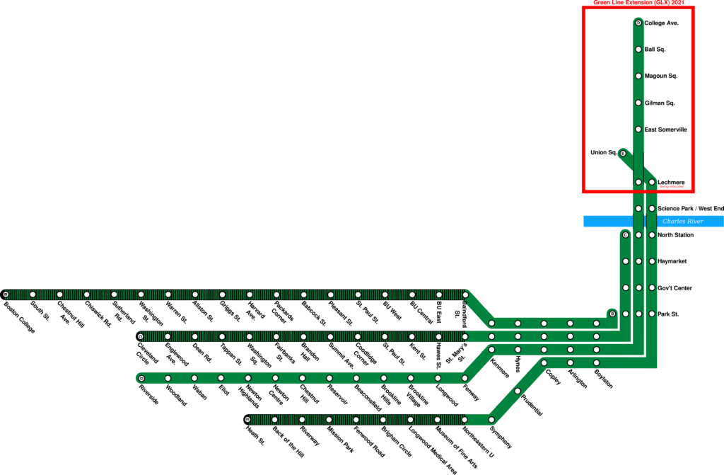
Today’s Green Line is about 37 kilometers in length,3 and consists of the Central Subway and 4 branches. They are named alphabetically from north to south, the B, C, D, and E respectively. On the western end, the Green Line serves dense urban areas like Brookline and the Allston/Brighton/Mission Hill neighborhoods of Boston, as well as the suburb of Newton on the D Branch. The A branch, serving Watertown, last ran revenue service in 1969, when it stopped running passenger service because of its long street-running segments, although it was not abandoned until 1994 because it allowed access to the Watertown Carhouse.
The Central Subway runs from Kenmore to Lechmere, and is the main trunk of the Green Line. The B, C, and D branches merge at Kenmore, and the E joins two stops later at Copley, where they run together through Downtown Boston. The B, C, and most of the E branch run in dedicated medians of busy arterials, while the D branch runs in a dedicated right of way, converted from commuter rail, similar to the Mattapan Line. The E is street-running for its last 5 stops, and this is the last street running section of track that sees revenue service.4
Each of the four branches individually runs at 6 minutes during the peak, 8 minutes midday, and 10 minutes on weekends, combining for headways of 1.5 minutes, 2 minutes, and 2.5 in the Central Subway, although bunching and unreliability are big problems on the Green Line. Electrification is 600V DC, and the line is at least double tracked everywhere with a quad track section between Boylston and Park Street,5 but in practice usually only two tracks are used.
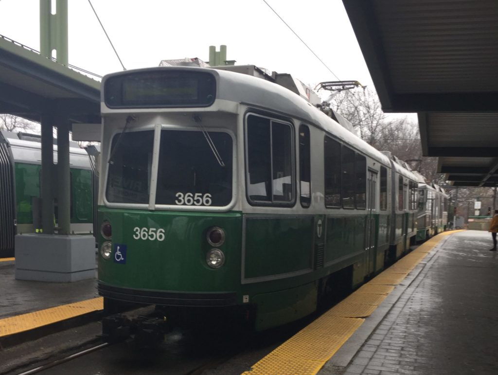
The Green Line runs 3 kinds of vehicles in revenue service: the Type 7, Type 8, and Type 9. The Type 7s, made by Kinki Sharyo, entered service in 1986, and have reliably served the MBTA since, with an additional order of 20 cars in 1997 and complete overhaul by Alstom from 2012 to 2019. The Type 8s, the MBTA’s first low floor vehicles, made by Ansaldo Breda, started to enter service in 1999, but were in and out of service until 2008 due to their notorious problems with braking and derailments,6 but by the 2010s, they were a mostly reliable fleet important to ADA compliance. The Type 9s, made by CAF, started to enter service in late 2018, and are a small order of 24 cars designed to add just enough service to keep headways the same when the Green Line Extension (GLX) will be completed.

There are pre-paid fare gates at every station in the Central Subway, as well as Riverside on the D Branch. At other surface stations, payment is done with onboard fareboxes. The fare is the standard $2.40, with free underground transfers to the other subway lines, and free transfers to bus at the major bus hubs at Lechmere and Kenmore, and other smaller bus hubs.
History
Origins and Pre MBTA
The origins of the Green Line start with Boston’s horsecar system. As typical of American transit development, it started from many companies rushing to build horsecar lines connecting the downtown to rapidly developing residential neighborhoods further out. Most of the systems in the immediate area around Boston were eventually taken over by the West End Street Railway. Electrification arrived relatively early in 1889.
Throughout the 1880s and 1890s, the sheer mass of streetcars flooding the downtown caused severe congestion, with a few blocks downtown even being triple tracked. This severe congestion led to multiple proposals for an either elevated or underground railway.

In 1894 the Boston Elevated Railway Company (BERy) was incorporated and chartered to construct an elevated railway in Boston, among the ideas considered was a monorail, but it was eventually decided on to build a rapid transit railway and a streetcar subway. The West End Street Railway was leased by the BERy in 1897 for 25 years, and officially incorporated into it in 1922.
The Tremont Street Subway opened in 1897 between Park Street and Boylston, along the busiest stretch of track in downtown along the Common.7 With two portals to the south and a loop at the north, it was quickly expanded from Park northward toward Scollay Square, where it branched into a loop, with a one way stop at Adams Square8 allowing streetcars from the north to turn around. Both directions merged at Haymarket, then rose above ground to North Station, where another northbound loop was located.

From 1901 to 1908 the Elevated Main Line, a rapid transit line, used inner tracks of the subway while its own downtown subway was being constructed, today this line is the Orange Line.
Throughout the early 20th century transit in Boston was quickly expanding, with new rapid transit lines being built, and the streetcar subway being expanded dramatically, first with the Causeway Street Elevated in 1912, which connected to the tunnel at North Station, then crossing over the Charles on the Lechmere viaduct. Then there was the Boylston Street Subway in 1914, which took the tunnel from Boylston Station under Back Bay, through stations at Arlington,9 Copley, and Mass Ave, to a ramp at Kenmore Square.
The original purpose of the streetcar subway was to simply replace some of the surface tracks downtown, this however, changed in 1922, when a terminal opened at Lechmere, and as opposed to earlier terminals, Lechmere was designed as a transfer station, where people could transfer from the streetcars from Somerville and Cambridge to the streetcars coming from downtown, meaning streetcars running in the subway formed some sort of a trunk which was now capped at the north. Some of the routes serving Lechmere were the busy lines from Egleston, Commonwealth Ave, or Beacon St.

Not much changed throughout the 30’s and 40’s.10 In 1941 the Huntington Avenue Subway opened, replacing the surface line via Commonwealth Avenue and Copley Sq. In 1947 the BERy was purchased by the city, and became the city-owned Metropolitan Transit Authority (MTA). The MTA started cutting streetcars throughout the 50’s. The lines running out of the subway to Charlestown were cut first, then the line to City Point. Despite the cuts, a major expansion happened in 1959, when the Riverside line opened (today the D). This line is notable in that it is a conversion of the Boston & Albany Railroad‘s Highland Branch, meaning it is similar to the Mattapan Line, and is also an example of rail to transit conversion in the US.
The 60’s brought more closures, and the line to Egleston, which had been shortened several times by that point, was finally killed. Its final form was a two stop shuttle between Boylston and Pleasant Street, and the elimination meant the the two flying junctions of the Pleasant Street portal were no longer in use, and they sit abandoned to this day. In 1964, the MTA was reorganized into the Massachusetts Bay Transportation Authority (MBTA), which, after a short while, rebranded the remaining lines as the Green Line, changing the paint scheme from orange-red 11 to a short lived gray, and finally to green.
MBTA

Also in the 60’s, a large portion of central Boston was cleared to build the city hall, which resulted in a reconstruction of the subway, which meant Scollay Square and Adams Square were removed and replaced with a simple two track tunnel and the station of Government Center, which contained two loops in both directions. In 1969, the northernmost branch of the system, the busy A to Watertown, was replaced with buses, partially due to equipment shortages from the new service on the then-10-year-old D.
The 70’s saw the arrival of the United States Standard Light Rail Vehicle (USSLRV), jointly procured by both the MBTA and Muni of San Francisco. It was built by Boeing Vertol and was the first modern LRV on the system, sadly though, it was fairly unreliable, resulting in the MBTA often salvaging units for parts, and at one point even storing dead LRVs at the abandoned Pleasant Street Portal.
In 1985, the southernmost branch, the E, was “temporarily” cut to half length, removing the section from Arborway to Heath Street that was mostly street-running, the MBTA cited track condition as the main reason. It wasn’t until 2011 that it was confirmed that streetcars will not be coming back to Arborway, despite multiple proposals to return to line to the dense neighborhood of Jamaica Plain. The PCCs, which were necessary as the line could not handle USSLRVs, were retired from the main system together with the cut.
Type 7s arrived in the late 80’s, and the USSLRV was replaced with the equally unreliable Type 8s throughout the early 2000’s. In 2004 the Causeway Street Elevated was replaced with a subway, and the loop at North Station was replaced with a turnaround track, though the Lechmere viaduct remained unchanged.
Future
The Green Line is currently in the middle of an expansion project that will extend the D and E branches northwest through Somerville and East Cambridge up to Medford. The E Branch is being extended one stop from Lechmere to Union Square, Somerville, down the existing Fitchburg Commuter Rail line right-of-way, and the D is being extended up to the Medford campus of Tufts University down the Lowell Commuter Rail line right-of-way. This project, the Green Line Extension (GLX) has been planned for a long time, and was one of the required transit projects the state has to build as part of Big Dig12 migitation. 13 This project was supposed to be complete by 2017, but the current opening date is 2021, with several cost overruns. 14 This is the first major Green Line project since 2004, 15and first new service since the D in 1959. The rapid transit system itself hasn’t been expanded since 1987, though there have been recent additions to the MBTA’s “bus rapid transit” lines. The GLX is projected to serve over 50,000 trips a day, and runs along the current busy 80 and 88 bus routes, which themselves descend from feeder streetcars of Lechmere.
Analyzation
Frequency: With 150 vehicles running at peak hours, frequencies are high, especially along the trunk, however, on the branches, especially the B and D, trains still often have to leave people behind,16 and in the Central Subway, passenger loads and delays often lead to trains stuck right behind each other, resulting in poor service. Given this, the MBTA has experimented with running 3 car trains, however apparently this lead to poor electrical and signal communication between the three cars, resulting in delays, and I believe 3 car trains were completely removed from the schedule by 2017. Because of this overcrowding, the MBTA would benefit from longer trains, something they are looking into for their next generation of cars, the Type 10.
Even without 3 car trains, reliability and performance are still low, because of equipment breakdowns or just the general pain of running such an old system with headways so tight in the Central Subway. On board fare collection slows things down a lot, so during rush hour most drivers open all doors and use the honor system, assuming those getting on in the back have monthly passes.
Intermodality: From the 2014 Blue Book,17 almost 60,000 passengers18 transferred between the Green and Red Lines at Park Street, so you can see the relatively well-connectedness of the hub-and-spoke MBTA system.19 Transfers are also available to the Blue Line at Government Center and the Orange Line at North Station,2021 and there are transfers to bus at a variety of stations.
Character: The line contains one of the only elevated sections of rail left on the MBTA, between Science Park and Lechmere, the 1912-built Lechmere Viaduct, which is currently being renovated. The line is then underground to Kenmore on the B, C, and D Branches, and to Symphony on the E Branch. Then the B, C, and E Branches run in medians, although the E Branch enters mixed-traffic for its last section between Brigham Circle and Heath Street, though the MBTA is proposing cutting the street running section as part of budget cuts. The D Branch runs in a dedicated right of way with no grade crossings except for a pedestrian crossing in Webster Conservation Area in Newton, where trains need to slow down and check for pedestrians. Level crossings on the B, C, and E do not slow down trains much, as they often are signalized with the parallel road, although service to the street-running section of the E is commonly suspended if there is an accident blocking the tracks. Many stations on the B, C, D, and street running portions of the E have platforms in poor shape and don’t have a tactile strip, and only stations on the D have fare vending machines, although you can add money to a CharlieCard or CharlieTicket with the onboard farebox with no additional fee. Every station on the D has a heated shelter, and most also have a wooden shelter and wastebaskets, and the E has shelter and benches at all median stations, while stations on other the other two branches are usually bare, with benches or shelter at only major stations. Accessibility is a major problem for the Green Line, with only 32 of 66 stations accessible.


The B Branch is notorious for being a slog, and famous for people being able to walk faster than the train,22 so much so that Boston College, the terminus of the line, runs a shuttle bus to Reservoir, the closest station on the D. The C Branch is known for a smooth but not necessarily quick ride into Boston, unlike the B. The D is just the express line for the suburbanites into the city, and the E is pretty good while it runs in the median, but its street running portion is often delayed, cascading to the rest of the branch.
As for the actual scenery of the line, the B Branch is a curvy ride down Commonwealth Avenue without much to see, while the C Branch is a straight shot down Beacon Street on a leafy median. The D Branch is woodsy before Reservoir, and after that it’s mostly the backs of buildings, and the E Branch goes down busy Huntington Ave, among all the offices and museums.
Type
This diverse system deserves at least 3 different labels in my opinion, but for the sake of the the blog, Meirk has told me to give it Light Rail of the subcategory Streetcar Subway. Light Rail for the branches, of course, as they are mostly separated from traffic, and Streetcar Subway, for, well, the subway. If we could give more labels, the D would get Suburban Light Rail because of its completely separated23 right of way through a suburb, being deprived of a Low Floor Metro only due to the lack of fare control. For a cheesy ending, we’ll just say that the Green Line was the first subway in America, and arguably one of the first proper light rail’s, and it continues to be a modern system that serves the Boston area relatively well.
We hope you have enjoyed this post, if you have any questions, comments, feedback? please do not hesitate to comment or contact us.
Yeah, this post definitely might’ve been too long.
One reply on “Boston Green Line: This Time, an Actual System”
The then new MTA accepted and imlemented the “Coolidge Report which recommended the elimination of all street running streetcar lines. During the late 1950’s early 1960’s MTA engaged a notably anti streetcar General Manager from NYC ( who had there implemented the end of what was left of Brooklyn’s streetcar system). In Boston he put an end to te Tremont St line but was unable to finish off the Watertown and Arborway lines before being fired. Recommend the Boston St Ry Associations MTA book for the full unabridged story.
Streetcar subways function just fine in many places world wide notably Germany and even here in the US in Phila, Newark,SF. MBTA management seems to be afflicted with the same negative attitude as the prior MTA management. They seem to want it to fail. Age is not a reason for poor operational procedures, lack of track maintenance and vehicle maintenance. I am at a complete loss as to why the boyston St subway was not reopened for a Washington St Light Rail line to replace the ‘El” in 1987!!