Prologue
Why on earth did you choose a quirky line in southern Boston as your first review!? Well, I don’t know actually, maybe because I’m currently in Boston… Maybe because I like PCCs… But from a practical standpoint it’s a short line that can be quickly described and serves as a template for myself, and a demonstration of what I will try to do in this blog.
If you don’t know about Tram Review, you can visit the about page. 😄
Overview
This “system” is located on the southern edge of Boston in the state of Massachusetts in the Northeastern United States, and about half of the line is located in the leafy suburb of Milton.
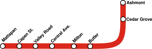
This “system” actually happens to be a single line, and it is commonly known as the Mattapan Line. It’s considered part of the Red Line Subway on maps, despite those being different modes of transport with no through service. The line begins at the busy transit center of Ashmont, and continues along the Neponset River to the bus terminal at Mattapan.

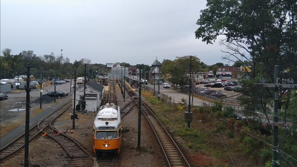
The line contains 8 stations and is composed of one service, totalling 4.09 kilometers1. Electrification is the standard 600V DC, and yes, like any good transit system, the line is double tracked. Now, what you have been waiting for: the rolling stock on the line totals at 10 PCC streetcars built by Pullman Standard in the late 40’s and early 50’s… They may be nostalgic, but it is certainly unusual, especially for a non-heritage service. The reason for this is that the numerous bridges on the line will need to be heavily modified to accommodate the weight of modern LRVs. This has resulted in PCCs, the last non-articulated units on the system, to stay on the Mattapan Line to this day.
As a rapid transit line, the schedule does not play an important role in the service itself, with frequencies of about 5 minutes at rush hour and a one-way trip taking about 9 minutes according to the schedule. Due to the length of the line, 6 circulating PCCs are generally enough to provide this. The frequency drops to something closer to 10 minutes midday before climbing up again to 5 minutes for the evening rush. Because the MBTA doesn’t run 24 hours a day, service ends at 1:15 am at night and starts at 5 am in the morning. Weekend service is 10-20 minutes on Saturdays and closer to half an hour on Sundays. In summary, the short length of the line enables the provision of high frequency service with limited amount of rolling stock.
Fares are standard MBTA subway fares, $2.40 with a CharlieCard, $2.90 with ticket or cash, and transfers provided to subway or bus. All of the stations (even Ashmont) are outside of fare control, and you pay on board.

History
How did we end up with this bespoke individual line? you may ask, well… First we have to start from the right of way. From Wikipedia:
The Dorchester and Milton Branch Railroad opened in December 1847 from Neponset on the Old Colony main line to Mattapan station in Dorchester via Milton Mills (later Milton Lower Mills, then simply Milton). The line was immediately leased by the Old Colony as its Milton branch. The Old Colony built the Shawmut Branch Railroad from Harrison Square on the main line to Milton Lower Mills via Peabody Square in 1872. Most Mattapan passenger service switched to use the new branch east of Milton, as it ran through dense urban neighborhoods rather than swamps. The Old Colony Railroad and its branches were acquired by the New York, New Haven and Hartford Railroad in 1893.
When the Boston Elevated Railway (BERy) was first constructing its rapid transit Cambridge–Dorchester line in the early 1910s, plans called for the line to be extended south from Andrew to Codman Square via Edward Everett Square, Columbia Square, and Mount Bowdoin. The route would have paralleled the New Haven’s Shawmut branch and Midland Division. By the end of that decade, however, passenger traffic on both New Haven-owned lines had been decimated by the BERy’s network of electrified streetcar lines, which connected to rapid transit trains at Forest Hills, Egleston, Dudley Square, and Andrew. Around 1920, BERy reached an agreement with the New Haven and the Boston Transit Commission to pursue the Dorchester Circuit Plan […]
Wikipedia, on Ashmont–Mattapan High-Speed Line
Wikipedia later goes to describe the Dorchester Circuit Plan which meant routing rapid transit through the branch, then out to today’s Fairmount line, and from there back to Andrew, though this never happened. Steam train service ended on the Shawmut Branch in 1927, and it was converted to rapid transit (forming today’s Ashmont Branch of the Red Line), but due to cost, the Boston Elevated decided to convert the part south of Ashmont to streetcar, and the Ashmont Mattapan High Speed Line, numbered 282, opened in 1929. It connected to the existing streetcar system at both Ashmont and Mattapan, and usually ran single car Type 4s. Named “high speed” due to its separation from traffic, it was an early example of rail to rapid transit conversion in the United States.

Starting in the 40’s, the streetcars this line complemented were starting to be replaced by trolleybuses and later buses. The last line connecting it to the rest of the streetcar system, the 29 from Mattapan to Egleston, was converted to bus in September 1955. This meant that the line lost direct access to heavy maintenance facilities, and in the 60’s cars had to be shuttled to Harvard coupled to Red Line trains… When the yard at Harvard was gone (Red Line Northwest Extension, 80’s), cars had to be trucked to Everett, and they continue to do today when in need of serious maintenance.
Extra: Snowplowing on the Mattapan Line
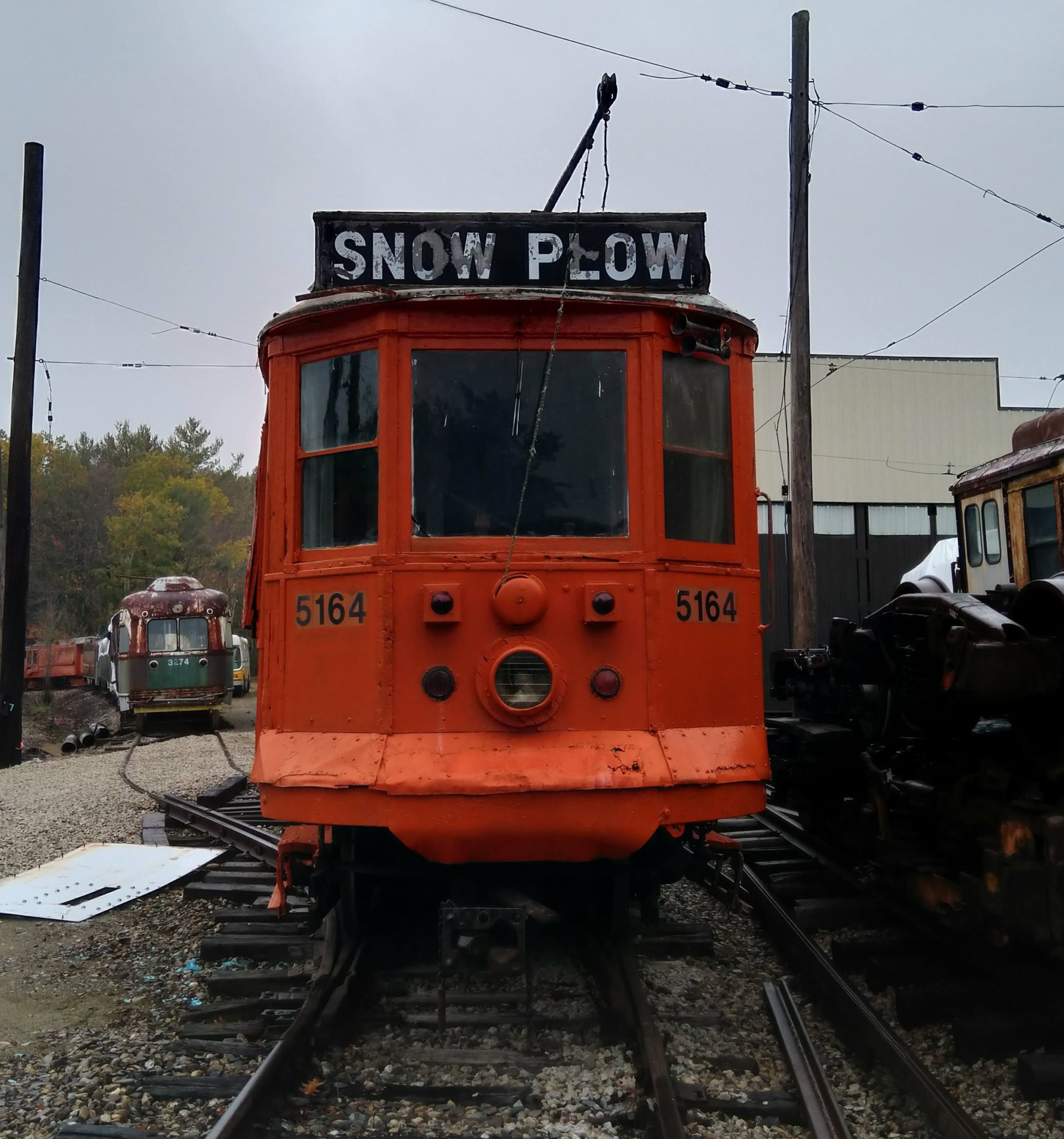
From its inception, snowplowing on the line was done using Type 3s converted to snowplows, relatively typical of the BERy at the time… The Type 3s continued to be used in Boston through the latter half of the 20th century, with the last Type 3 snowplow being retired from the line in 2006. The streetcar was 99 years old at the time of retirement.3 Well, what were the Type 3s replaced with? By 2007 all of the USSLRVs on the main system had been retired, so some USSLRV bogies had plows attached to them so they could be pushed by a Type 7. The problem with the Mattapan Line is, there aren’t any Type 7s, and PCCs can’t exactly push anything, so they got a jet powered snowblower! Yeah… Wikipedia has some more info on it so go read there. Apparently it wasn’t exactly very reliable, and there were instances of the MBTA borrowing Type 3s from museums when existing plowing equipment wasn’t enough.
Analyzation

Frequency: As noted earlier, due to the length of the line, high frequency can be provided with limited rolling stock, so I’d assume the frequency is fitting, and from my experiences of riding and watching the line I would not say it was overcrowded, empty, or infrequent.
Intermodality: Boston probably has one of the most integrated systems in the US (not exactly impressive, but still something) so it’s no wonder that the CharlieCard system allows for Subway-Bus transfers, although sadly the platform at Ashmont is outside fare control, preventing seamless transfers. The line connects to many buses at both Ashmont and Mattpan. Buses departing from Ashmont generally serve the dense neighborhoods of Dorchester and Roxbury, and buses departing from Mattapan additionally serve the slightly less dense areas of Hyde Park and Readville in the far southern corner of Boston. We also must not forget that the main purpose of the Mattapan line is to connect Mattapan to the Red line at Ashmont… so it’s designed for transfers.
Character: The line is mostly at surface level, except for the platform at Ashmont, which is elevated, and the flying junction at Shawmut.4 The line is mostly grade separated (probably due to its proximity to the river), except for Capen Street, which is a dead end, so it’s not very significant, and Central Avenue which is a fairly central avenue… This level crossing probably delays many trips and the lack of crossing gates doesn’t help either. Stations are simple, with most containing a bench, a bin, a departure board, and a shelter, and also wheelchair lifts for accessibility. The lack of ticket vending machines as opposed to the Green Line D Branch 5 is notable, and could be considered an inconvenience for non-regular riders. The terminal stations of Ashmont and Mattapan are grander, shall we say. Ashmont, also serving a subway line, is fully enclosed, has a lot of shelter, and even a cafe if I remember correctly, with the last being a rarity for subway stations but the rest being standard. Mattapan has more shelter than other stations,6 three platforms, and two busways (also a light maintenance shed but that’s not relevant).
The line follows the Neponset River for most of its route, and the paralleling branch line has been converted into a trail, offering a pleasant walk if you have the time.
Type & Rating
Considering there is nothing reviewed to compare this line to… there’s the need to create semi-broad definitions into which those systems should fall. I think this line deserves the classification of Suburban Light Rail. Light rail due to its separation from traffic and fairly high speeds, and suburban as it mostly serves the suburb of Milton, and the more urban Ashmont and Mattapan only at the ends. The older rolling stock and simpler stations certainly do lower the quality of the line, but do not prevent it from providing a convenient transit service to many people.

We hope you have enjoyed this post, if you have any questions, comments, feedback? please do not hesitate to comment or contact us.
One reply on “Ashmont Mattapan High Speed Line: Quirky yet Convenient”
[…] of the Boston & Albany Railroad‘s Highland Branch, meaning it is similar to the Mattapan Line, and is also an example of rail to transit conversion in the […]